US makes embarrassing African map blunder (PHOTO)
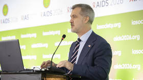
A US government map misplaced every African country it highlighted during a presentation at a major international AIDS conference, prompting an apology from the State Department.
The map appeared on Sunday during a presentation by Jeff Graham, the top US health official overseeing the President’s Emergency Plan for AIDS Relief (PEPFAR), at the AIDS 2026 Conference in Rio de Janeiro. The session focused on Washington’s new health funding agreements with African governments, but all six countries identified on the map were incorrectly positioned.
Nigeria was placed in the Sahara, making the West African coastal nation appear landlocked, while Mozambique was moved from southeastern Africa to the Horn of Africa. Ivory Coast (Cote d’Ivoire) appeared on the opposite side of the continent, and the locations or borders of Cameroon, Malawi, and Uganda were also inaccurate.
An examination of the image found a watermark indicating that it had been created using OpenAI technology, Reuters reported. The company was quoted as saying that it is investigating the incident.
The State Department said it takes “full responsibility for the confusion and misrepresentation” caused by the blunder, including among its African partners.
“This was an unfortunate error caused by a team member who hastily altered the slide deck immediately before the presentation at the AIDS 2026 Conference,” a State Department spokesperson said on Thursday.
🇺🇸🌍 The U.S. State Department can’t even locate African countries on a map.
— DD Geopolitics (@DD_Geopolitics) July 30, 2026
During an official presentation in Rio de Janeiro, the American delegation displayed an AI-generated map placing Nigeria in the Sahara, Mozambique on the Horn of Africa, and Côte d’Ivoire on the… pic.twitter.com/3iuvPRr7gH
The error was first publicized by AIDS campaigner Emily Bass, who described the slide as “disrespectful to African collaborators.” Matt Petit, an artificial intelligence and geopolitics specialist at the Atlantic Council, said whoever created and approved it “did not know where countries in Africa are and did not care to check their work.”
The presentation concerned Washington’s America First Global Health Strategy, introduced as part of an overhaul of foreign assistance following the dismantling of the US Agency for International Development after President Donald Trump returned to office last year.
The State Department says agreements concluded with 34 countries include more than $14.3 billion in US assistance and $9.6 billion in investment from recipient governments. However, the initiative has faced resistance elsewhere in Africa. Ghana and Zimbabwe rejected proposed agreements over demands for access to sensitive health data, while Zambia suspended negotiations in May over data provisions and Washington’s attempt to link health assistance to a critical-minerals deal. Kenya signed a five-year agreement in December, but its implementation has faced a legal challenge over privacy and constitutional concerns.
The map incident is not the first geographical gaffe by a US administration. In 2017, Donald Trump twice pronounced Namibia as “Nambia” while addressing African leaders. In 2022, Joe Biden thanked Colombia instead of Cambodia for hosting an ASEAN summit in Phnom Penh, according to the official White House transcript.